East Fork of the White River – Bedford to Williams.
Several folks request this trip and it is good for fishing from big Old Town fishing kayaks, and motorboats. The current is slow and the sandbars are all submerged due to the effect of Williams dam backing up water over the sandbars. This means, for kayakers, there are not many places to get out to take a break, and the trip requires a lot of paddling. However, one very good place to take a break is at the mouth of Salt Creek.
The fishing for catfish, walleyes, stripers, wipers, white bass, and spotted bass is good on this stretch of river.
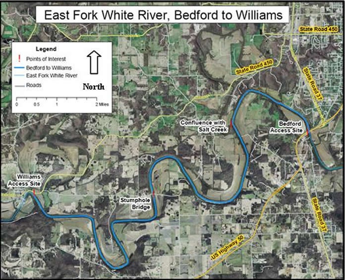
This 15-mile section from the Bedford Public Access Site to Williams Dam is a 61/2 hour float. The river meanders through a corridor of maples, willows and sycamore. This stretch is very good fishing but the current is slow and there are no sandbars to take a break on. They are submerged by the backed up water from Williams Dam. This trip requires a lot of paddling effort.
The Bedford Public Access Site is on the southeast side of the St. Rd. 37 bridge with ample parking. The take-out is the Spice Valley Public Access Site just upstream of Williams Dam.
$80 per Solo Kayak
$140 per Tandem Kayak
$140 for an Old Town Sportsman Fishing Kayak
$60 for the shuttle only
GPS Coordinates
Bedford Ramp (hwy 37 & 50) (542224mE, 4297478mN)
Highway exit point for Bedford ramp (542090mE, 4297432mN)
Confluence of Salt Creek & EFWR (539197mE, 4297833mN)
Stumphole Bridge (536014mE, 4295013mN)
Williams Ramp (531221mE, 4295057mN)
Highway exit point for Williams ramp (531256mE, 4295064mN)